Typhoon Koinu at shock level 17 heads towards East Sea
According to the National Centre for Hydro-Meteorological Forecasting, on October 3, a strong storm with the international name Koinu located in the northeastern sea of Luzon island in the Philippines, intensified significantly.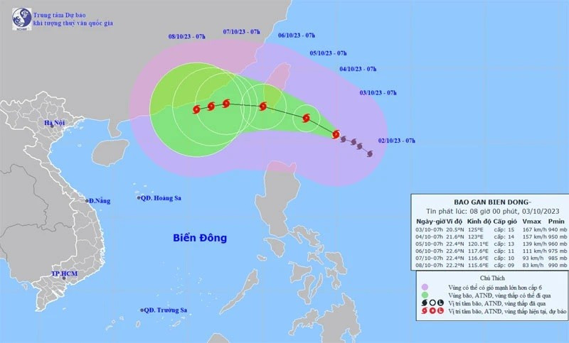
As of 7 am on October 3, the storm's center was located around 20.5 degrees North latitude and 125.0 degrees East longitude, situated in the northeastern sea near Luzon Island in the Philippines. The most intense winds near the storm's centre were at level 15 (167-183 kilometres per hour), with gusts exceeding level 17.
The storm was moving northwestward at an approximate speed of 10 kilometres per hour. It is forecasted that, in the coming days, the storm could have an impact on the northeastern region of the East Sea/South China Sea.
By 7 am on October 4, the storm's center will be at about 21.6 degrees North latitude; and 123.0 degrees East longitude. The most intense wind near the centre of the storm will be level 14-15, with gusts exceeding level 17. The storm will be moving northwestward at an approximate speed of 10 kilometres per hour.
On the morning of October 5, the storm's center will be at about 22.4 degrees North latitude; and 120.0 degrees East longitude. Over 72 hours, storm Koinu will likely change its direction and move westward at a speed of about 10km per hour.
By 7 a.m. on October 6, the storm's center will be at about 22.6 degrees north latitude; and 117.6 degrees east longitude. The strongest wind near the centre of the storm is expected at level 11, gusting to level 13, moving westward at an approximate speed of 10 kilometres per hour.
Due to the impact of storm Koinu, there will be strong winds and rough seas occurring in the North East Sea region from the night of October 3, with sea waves reaching between five metres and seven metres high.